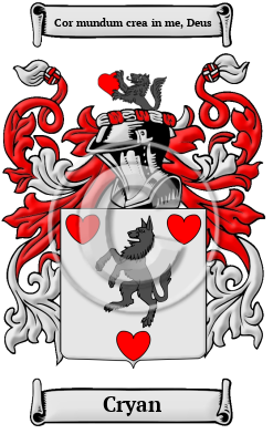
| ![Show Contents]() Cryan History, Family Crest & Coats of Arms Cryan History, Family Crest & Coats of Arms
- Origins Available:
Ireland
Etymology of CryanWhat does the name Cryan mean? The Irish name Cryan has a long Gaelic heritage to its credit. The original Gaelic form of the name Cryan is Ó Croidheagain, from the word "croidhe," which means "heart." 1 Early Origins of the Cryan familyThe surname Cryan was first found in Donegal (Irish: Dún na nGall), northwest Ireland in the province of Ulster, sometimes referred to as County Tyrconnel, where they held a family seat from ancient times. Early History of the Cryan familyThis web page shows only a small excerpt of our Cryan research. Another 65 words (5 lines of text) covering the year 1616 is included under the topic Early Cryan History in all our PDF Extended History products and printed products wherever possible. Cryan Spelling VariationsIrish names were rarely spelled consistently in the Middle Ages. Spelling variations of the name Cryan dating from that time include Cregan, Crean, O'Crean, O'Cryan, Creaghan, Creegan, Creahan, Crehan, Creane and many more. Early Notables of the Cryan familyMore information is included under the topic Early Cryan Notables in all our PDF Extended History products and printed products wherever possible.
| Cryan migration to the United States | + |
The 19th century saw a great wave of Irish families leaving Ireland for the distant shores of North America and Australia. These families often left their homeland hungry, penniless, and destitute due to the policies of England. Those Irish immigrants that survived the long sea passage initially settled on the eastern seaboard of the continent. Some, however, moved north to a then infant Canada as United Empire Loyalists after ironically serving with the English in the American War of Independence. Others that remained in America later joined the westward migration in search of land. The greatest influx of Irish immigrants, though, came to North America during the Great Potato Famine of the late 1840s. Thousands left Ireland at this time for North America, and those who arrived were immediately put to work building railroads, coal mines, bridges, and canals. In fact, the foundations of today's powerful nations of the United States and Canada were to a larger degree built by the Irish. Archival documents indicate that members of the Cryan family relocated to North American shores quite early:
Cryan Settlers in United States in the 19th Century- Bridget Cryan, who arrived in New York, NY in 1816 2
- Catharine Cryan, who landed in New York, NY in 1816 2
- Catherine Cryan, who landed in New York, NY in 1816 2
- James Cryan, who arrived in New York, NY in 1816 2
- Martin Cryan, who landed in New York, NY in 1816 2
- ... (More are available in all our PDF Extended History products and printed products wherever possible.)
| Cryan migration to Canada | + |
Some of the first settlers of this family name were: Cryan Settlers in Canada in the 19th Century- Michael Cryan, who landed in Canada in 1812
- Michael Cryan, aged 20, who arrived in Canada in 1812
- Mary Cryan, aged 13, who arrived in Saint John, New Brunswick in 1834 aboard the ship "Britannia" from Sligo, Ireland
- Maurice Cryan, aged 12, who arrived in Saint John, New Brunswick in 1834 aboard the ship "Britannia" from Sligo, Ireland
- Michael Cryan, aged 13, who arrived in Saint John, New Brunswick in 1834 aboard the ship "Britannia" from Sligo, Ireland
| Contemporary Notables of the name Cryan (post 1700) | + |
- Joseph Cryan, American Democratic Party politician, Member of Democratic National Committee from New Jersey, 2004; New Jersey Democratic State Chair, 2008 3
- Arthur Chester Cryan (1884-1950), American Republican politician, Express agent; Elected New Hampshire State House of Representatives from Lancaster 1938 3
- John F. Cryan (1929-2005), American Democratic Party politician, Member of the New Jersey General Assembly and as the Essex County Sheriff, father of Joseph Cryan
- Joseph Cryan (b. 1961), American Democratic Party politician, Member of the New Jersey General Assembly (2002-)
- Thomas Columba Cryan (1929-2024), Irish Gaelic footballer who played at club level with Ballinamore Seán O'Heslin's and at inter-county level with the Leitrim senior football team
- Frances Cryan, Irish Olympic rower who competed at the 1980 Summer Olympics
- Colin Cryan (b. 1981), Irish born professional footballer
- Robert Cryan (1827-1881), Irish medical doctor, professor of Anatomy and Physiology at the Catholic University in Dublin
- John Cryan (b. 1960), British businessman, Group Chief Financial Officer at UBS AG, former chief executive of Deutsche Bank AG (2015-2018)
- Carmel Cryan (b. 1949), English actress, best known for her role as Brenda Boyle in the BBC soap opera, EastEnders
The motto was originally a war cry or slogan. Mottoes first began to be shown with arms in the 14th and 15th centuries, but were not in general use until the 17th century. Thus the oldest coats of arms generally do not include a motto. Mottoes seldom form part of the grant of arms: Under most heraldic authorities, a motto is an optional component of the coat of arms, and can be added to or changed at will; many families have chosen not to display a motto.
Motto: Cor mundum crea in me, Deus
Motto Translation: Create in me a clean heart, O God.
- MacLysaght, Edward, The Surnames of Ireland. Ireland: Irish Academic Press, sixth edition, 1985. Print. (ISBN 0-7165-2366-3)
- Filby, P. William, Meyer, Mary K., Passenger and immigration lists index : a guide to published arrival records of about 500,000 passengers who came to the United States and Canada in the seventeenth, eighteenth, and nineteenth centuries. 1982-1985 Cumulated Supplements in Four Volumes Detroit, Mich. : Gale Research Co., 1985, Print (ISBN 0-8103-1795-8)
- The Political Graveyard: Alphabetical Name Index. (Retrieved 2015, November 2) . Retrieved from http://politicalgraveyard.com/alpha/index.html
 |

