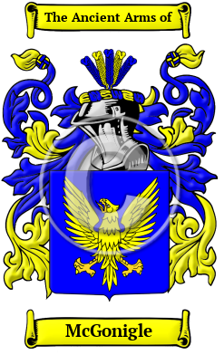
| ![Show Contents]() McGonigle History, Family Crest & Coats of Arms McGonigle History, Family Crest & Coats of Arms
- Origins Available:
Ireland Etymology of McGonigleWhat does the name McGonigle mean? Irish names tend to vary widely in their spelling and overall form. The original Gaelic form of the name McGonigle is Mag Congail, which means son of the most valorous one. Early Origins of the McGonigle familyThe surname McGonigle was first found in County Donegal (Irish: Dún na nGall), northwest Ireland in the province of Ulster, sometimes referred to as County Tyrconnel, where they held a family seat from ancient times. Early History of the McGonigle familyThis web page shows only a small excerpt of our McGonigle research. Another 83 words (6 lines of text) are included under the topic Early McGonigle History in all our PDF Extended History products and printed products wherever possible. McGonigle Spelling VariationsBefore widespread literacy came to Ireland, a name was often recorded under several different variations during the life of its bearer. Accordingly, numerous spelling variations were revealed in the search for the origin of the name McGonigle family name. Variations found include MacGonigle, MacGonagle, Magonagle, Magonigele and many more. Early Notables of the McGonigle familyMore information is included under the topic Early McGonigle Notables in all our PDF Extended History products and printed products wherever possible.
| McGonigle migration to the United States | + |
During the 19th century thousands of impoverished Irish families made the long journey to British North America and the United States. These people were leaving a land that had become beset with poverty, lack of opportunity, and hunger. In North America, they hoped to find land, work, and political and religious freedoms. Although the majority of the immigrants that survived the long sea passage did make these discoveries, it was not without much perseverance and hard work: by the mid-19th century land suitable for agriculture was short supply, especially in British North America, in the east; the work available was generally low paying and physically taxing construction or factory work; and the English stereotypes concerning the Irish, although less frequent and vehement, were, nevertheless, present in the land of freedom, liberty, and equality for all men. The largest influx of Irish settlers occurred with Great Potato Famine during the late 1840s. Research into passenger and immigration lists has brought forth evidence of the early members of the McGonigle family in North America:
McGonigle Settlers in United States in the 19th Century- Pat McGonigle, who landed in Alaska in 1893 1
- Francis McGonigle, aged 27, who landed in America from Fermanagh, in 1893
McGonigle Settlers in United States in the 20th Century- Joseph McGonigle, aged 22, who landed in America from Donegal, in 1903
- Hugh McGonigle, aged 30, who settled in America from Tyrone, Ireland, in 1904
- Adele McGonigle, aged 22, who immigrated to the United States from Donegal, Ireland, in 1904
- Bridget McGonigle, aged 20, who settled in America from Donegal, Ireland, in 1904
- Cassie McGonigle, aged 18, who immigrated to the United States from Donegal, in 1906
- ... (More are available in all our PDF Extended History products and printed products wherever possible.)
| McGonigle migration to New Zealand | + |
Emigration to New Zealand followed in the footsteps of the European explorers, such as Captain Cook (1769-70): first came sealers, whalers, missionaries, and traders. By 1838, the British New Zealand Company had begun buying land from the Maori tribes, and selling it to settlers, and, after the Treaty of Waitangi in 1840, many British families set out on the arduous six month journey from Britain to Aotearoa to start a new life. Early immigrants include: McGonigle Settlers in New Zealand in the 19th Century- Patrick McGonigle, aged 19, a farm labourer, who arrived in Auckland, New Zealand aboard the ship "Queen of Nations" in 1874
| Contemporary Notables of the name McGonigle (post 1700) | + |
- Arthur T. "Art" McGonigle (1905-1977), Pennsylvania businessman and the 1958 Republican Party nominee for state governor
- William C. McGonigle, American Democratic Party politician, Delegate to Democratic National Convention from Hawaii Territory, 1936 2
- Victor J. McGonigle, American Democratic Party politician, Candidate for U.S. Representative from Nebraska 3rd District, 1940 2
- John M. McGonigle, American Democratic Party politician, Candidate for Wisconsin State Assembly from Dane County 2nd District, 1938; Member of Wisconsin Democratic State Central Committee, 1954 2
- B. E. McGonigle, American Democratic Party politician, Delegate to Democratic National Convention from Wisconsin, 1936 2
- Arthur T. McGonigle, American Republican politician, Delegate to Republican National Convention from Pennsylvania, 1956, 1960; Candidate for Governor of Pennsylvania, 1958 2
- Colm McGonigle, Irish soccer player
- Jerry McGonigle, American award-winning Associate Professor of Acting and Directing at West Virginia University
- Brendan O. McGonigle (1939-2007), British University of Edinburgh psychology reader
- Filby, P. William, Meyer, Mary K., Passenger and immigration lists index : a guide to published arrival records of about 500,000 passengers who came to the United States and Canada in the seventeenth, eighteenth, and nineteenth centuries. 1982-1985 Cumulated Supplements in Four Volumes Detroit, Mich. : Gale Research Co., 1985, Print (ISBN 0-8103-1795-8)
- The Political Graveyard: Alphabetical Name Index. (Retrieved 2016, January 14) . Retrieved from http://politicalgraveyard.com/alpha/index.html
 |

